Anacortes night lights from space
Night Light of Anacortes (Washington) from space (United States) Src. Average luminocity for 10x10km area is 20.7983% and for 50x50km: 4.9848%.
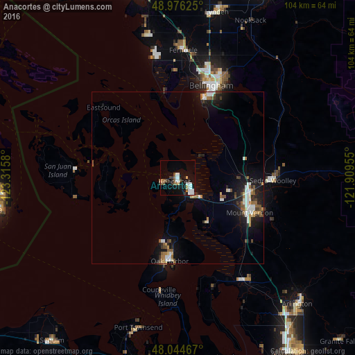
Analysis of Anacortes night lights 2016
Square area 10x10 km:
 5.68%
5.68%90-99
3.98%80-89
0.99%70-79
1.28%60-69
1.28%50-59
3.27%40-49
1.85%30-39
2.13%20-29
1.7%10-19
18.32%0-9
59.52%Square area 50x50 km:
0.89%90-99
0.82%80-89
0.3%70-79
0.37%60-69
0.64%50-59
0.77%40-49
0.44%30-39
0.56%20-29
1.03%10-19
4.67%0-9
89.48%Clear (daylight) street map image can be seen on geolist.org.
Map coordinates:
48° 58' 34.5" North, 123° 18' 56.9" West
48° 30' 45.4" North, 122° 36' 45.6" West
48° 2' 40.8" North, 121° 54' 34.4" West
Some cities around Anacortes sort by population:
• Bellingham
28.9 km =18 mi,  18°
18°
• Mount Vernon
22.9 km =14.2 mi,  116°
116°
• Oak Harbor
24.5 km =15.2 mi,  185°
185°
• Ferndale
37.2 km =23.1 mi,  2°
2°
• Sedro-Woolley
27.8 km =17.3 mi,  91°
91°
• Burlington
21.6 km =13.4 mi,  100°
100°
• Stanwood
35.1 km =21.8 mi,  149°
149°
• Sudden Valley
30.5 km =19 mi,  39°
39°
5785657 (p: 16,403)
Sources (retrieved 2019-11-25):
» Earth at Night: Flat Maps 2012, 2016