Hudson night lights from space
Night Light of Hudson (Massachusetts) from space (United States) Src. Average luminocity for 10x10km area is 46.6603% and for 50x50km: 36.7616%.
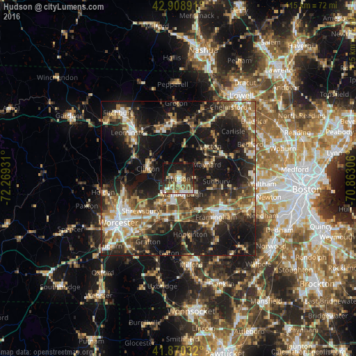
Analysis of Hudson night lights 2016
Square area 10x10 km:
 5.24%
5.24%90-99
9.37%80-89
7.3%70-79
6.83%60-69
6.03%50-59
10.48%40-49
6.19%30-39
4.29%20-29
13.97%10-19
27.78%0-9
2.54%Square area 50x50 km:
4.2%90-99
5.48%80-89
4.59%70-79
4.02%60-69
5.56%50-59
6.87%40-49
6.84%30-39
6.97%20-29
12.68%10-19
26.75%0-9
16.04%Clear (daylight) street map image can be seen on geolist.org.
Map coordinates:
42° 54' 32.1" North, 72° 16' 9.5" West
42° 23' 30.3" North, 71° 33' 58.2" West
41° 52' 13.2" North, 70° 51' 47" West
Some cities around Hudson sort by population:
• Marlborough
5.2 km =3.2 mi,  167°
167°
• Maynard
10.6 km =6.6 mi,  64°
64°
• Southborough
10.2 km =6.3 mi,  160°
160°
• Lancaster
11.3 km =7 mi,  308°
308°
• Clinton
10 km =6.2 mi,  286°
286°
• Northborough
10.1 km =6.3 mi,  217°
217°
• Harvard
12.1 km =7.5 mi,  353°
353°
• Stow
7.1 km =4.4 mi,  44°
44°
4940094 (p: 14,907)
Sources (retrieved 2019-11-25):
» Earth at Night: Flat Maps 2012, 2016