White Oak night lights from space
Night Light of White Oak (Pennsylvania) from space (United States) Src. Average luminocity for 10x10km area is 60.8673% and for 50x50km: 48.4021%.
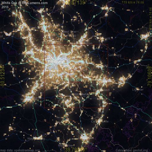
Analysis of White Oak night lights 2016
Square area 10x10 km:
 4.25%
4.25%90-99
8.5%80-89
7.82%70-79
11.73%60-69
15.99%50-59
18.2%40-49
18.71%30-39
9.86%20-29
4.93%10-19
0%0-9
0%Square area 50x50 km:
7.7%90-99
8.86%80-89
6.15%70-79
7.39%60-69
9.35%50-59
9.28%40-49
7.03%30-39
6.48%20-29
10.76%10-19
12.62%0-9
14.39%Clear (daylight) street map image can be seen on geolist.org.
Map coordinates:
40° 52' 17" North, 80° 30' 44.4" West
40° 20' 15.3" North, 79° 48' 33.2" West
39° 47' 58.2" North, 79° 6' 21.9" West
Some cities around White Oak sort by population:
• Monroeville
9.5 km =5.9 mi,  10°
10°
• West Mifflin
5.6 km =3.5 mi,  300°
300°
• McKeesport
4.8 km =3 mi,  283°
283°
• North Versailles
4.7 km =2.9 mi,  359°
359°
• Wilson
7.6 km =4.7 mi,  246°
246°
• Clairton
7.9 km =4.9 mi,  230°
230°
• Duquesne
6.5 km =4 mi,  318°
318°
• Turtle Creek
7.7 km =4.8 mi,  349°
349°
5219216 (p: 7,775)
Sources (retrieved 2019-11-25):
» Earth at Night: Flat Maps 2012, 2016