North Springfield night lights from space
Night Light of North Springfield (Virginia) from space (United States) Src. Average luminocity for 10x10km area is 86.9031% and for 50x50km: 70.9333%.
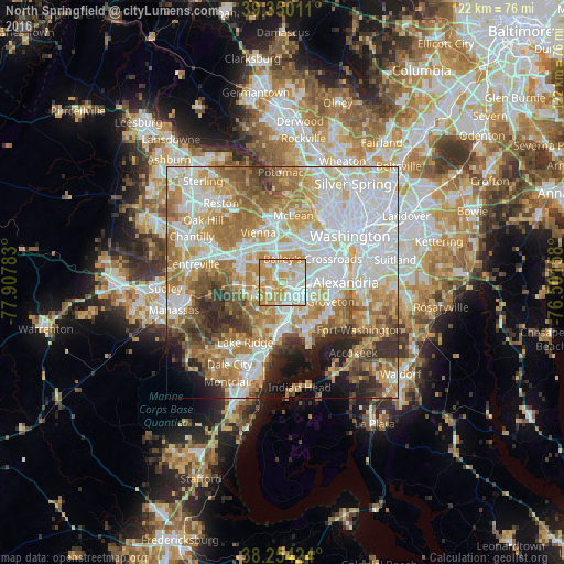
Analysis of North Springfield night lights 2016
Square area 10x10 km:
 24.15%
90-99
23.81%80-89
15.31%70-79
30.95%60-69
5.78%50-59
0%40-49
0%30-39
0%20-29
0%10-19
0%0-9
0%Square area 50x50 km:
21.03%90-99
16.1%80-89
9.37%70-79
12.26%60-69
11.49%50-59
7.41%40-49
4.79%30-39
4.65%20-29
5.14%10-19
4.85%0-9
2.91%Clear (daylight) street map image can be seen on geolist.org.
Map coordinates:
39° 21' 0.4" North, 77° 54' 28.2" West
38° 48' 15.4" North, 77° 12' 16.9" West
38° 15' 15.3" North, 76° 30' 5.7" West
Some cities around North Springfield sort by population:
• Burke
5.9 km =3.7 mi,  258°
258°
• Annandale
3 km =1.9 mi,  13°
13°
• Springfield
2.3 km =1.4 mi,  137°
137°
• Lincolnia
5.5 km =3.4 mi,  73°
73°
• West Springfield
3.8 km =2.4 mi,  201°
201°
• Franconia
5.6 km =3.5 mi,  116°
116°
• Lake Barcroft
6.4 km =4 mi,  41°
41°
• Woodburn
5.5 km =3.4 mi,  330°
330°
4776472 (p: 7,274)
Sources (retrieved 2019-11-25):
» Earth at Night: Flat Maps 2012, 2016