Lake Barcroft night lights from space
Night Light of Lake Barcroft (Virginia) from space (United States) Src. Average luminocity for 10x10km area is 93.4524% and for 50x50km: 75.8102%.
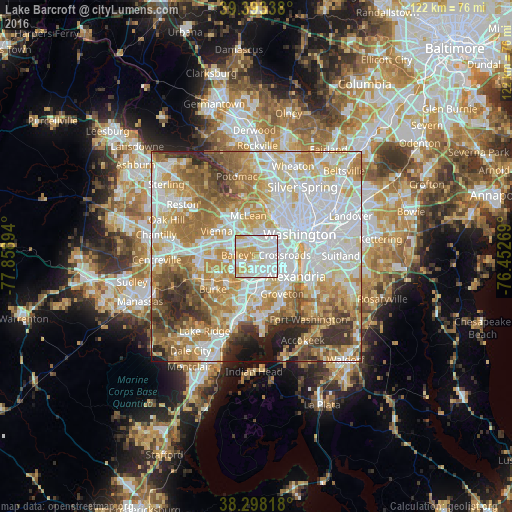
Analysis of Lake Barcroft night lights 2016
Square area 10x10 km:
 42.18%
90-99
28.91%80-89
12.93%70-79
15.99%60-69
0%50-59
0%40-49
0%30-39
0%20-29
0%10-19
0%0-9
0%Square area 50x50 km:
23.78%90-99
17.59%80-89
10.64%70-79
12.91%60-69
10.88%50-59
7.58%40-49
4.85%30-39
4.79%20-29
4.45%10-19
2.28%0-9
0.26%Clear (daylight) street map image can be seen on geolist.org.
Map coordinates:
39° 23' 36.2" North, 77° 51' 32.2" West
38° 50' 52.4" North, 77° 9' 20.9" West
38° 17' 53.4" North, 76° 27' 9.7" West
Some cities around Lake Barcroft sort by population:
• Arlington
5.8 km =3.6 mi,  50°
50°
• Annandale
4 km =2.5 mi,  241°
241°
• West Falls Church
3.4 km =2.1 mi,  304°
304°
• Baileys Crossroads
2.3 km =1.4 mi,  82°
82°
• Lincolnia
3.4 km =2.1 mi,  161°
161°
• Falls Church
4.1 km =2.5 mi,  340°
340°
• Seven Corners
2.7 km =1.7 mi,  1°
1°
• North Springfield
6.4 km =4 mi,  221°
221°
4768185 (p: 9,558)
Sources (retrieved 2019-11-25):
» Earth at Night: Flat Maps 2012, 2016