Madison night lights from space
Night Light of Madison (Connecticut) from space (United States) Src. Average luminocity for 10x10km area is 14.7938% and for 50x50km: 12.1811%.
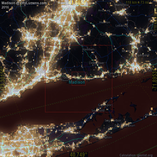
Analysis of Madison night lights 2016
Square area 10x10 km:
 0%
0%90-99
0%80-89
3.08%70-79
0.16%60-69
3.25%50-59
2.27%40-49
4.71%30-39
3.73%20-29
4.06%10-19
3.9%0-9
74.84%Square area 50x50 km:
0.96%90-99
1.42%80-89
1.57%70-79
1.86%60-69
1.99%50-59
2.46%40-49
2.6%30-39
2.29%20-29
2.98%10-19
5.93%0-9
75.93%Clear (daylight) street map image can be seen on geolist.org.
Map coordinates:
41° 48' 20.9" North, 73° 18' 5.6" West
41° 16' 46.3" North, 72° 35' 54.3" West
40° 44' 56.4" North, 71° 53' 43.1" West
Some cities around Madison sort by population:
• Branford
18.1 km =11.2 mi,  270°
270°
• East Haven
22.6 km =14 mi, 269°
• North Haven
25.1 km =15.6 mi,  299°
299°
• Guilford
7 km =4.3 mi,  278°
278°
• North Branford
15.1 km =9.4 mi,  290°
290°
• Old Saybrook
18.6 km =11.6 mi,  85°
85°
• East Haddam
22.4 km =13.9 mi,  30°
30°
• Branford Center
18.1 km =11.2 mi, 269°
4838116 (p: 19,100)
Sources (retrieved 2019-11-25):
» Earth at Night: Flat Maps 2012, 2016