Newport night lights from space
Night Light of Newport (Arkansas) from space (United States) Src. Average luminocity for 10x10km area is 24.5804% and for 50x50km: 2.7128%.
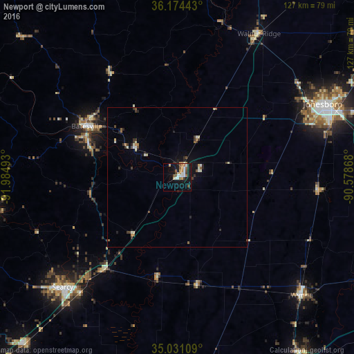
Analysis of Newport night lights 2016
Square area 10x10 km:
 4.37%
4.37%90-99
3.5%80-89
2.97%70-79
3.85%60-69
2.45%50-59
5.07%40-49
1.57%30-39
2.1%20-29
1.4%10-19
26.05%0-9
46.68%Square area 50x50 km:
0.27%90-99
0.48%80-89
0.28%70-79
0.27%60-69
0.25%50-59
0.41%40-49
0.23%30-39
0.64%20-29
0.44%10-19
1.85%0-9
94.88%Clear (daylight) street map image can be seen on geolist.org.
Map coordinates:
36° 10' 27.9" North, 91° 59' 5.7" West
35° 36' 17.3" North, 91° 16' 54.5" West
35° 1' 51.9" North, 90° 34' 43.2" West
Some cities around Newport sort by population:
• Jonesboro
58.4 km =36.3 mi,  63°
63°
• Searcy
57 km =35.4 mi,  226°
226°
• Forrest City
80 km =49.7 mi,  146°
146°
• Batesville
37.3 km =23.2 mi,  299°
299°
• Wynne
61.6 km =38.3 mi,  133°
133°
• Heber Springs
69 km =42.9 mi,  259°
259°
• Trumann
70.4 km =43.7 mi,  83°
83°
• Pocahontas
78.2 km =48.6 mi,  20°
20°
4123830 (p: 7,767)
Sources (retrieved 2019-11-25):
» Earth at Night: Flat Maps 2012, 2016