Pocahontas night lights from space
Night Light of Pocahontas (Arkansas) from space (United States) Src. Average luminocity for 10x10km area is 21.1696% and for 50x50km: 2.0436%.
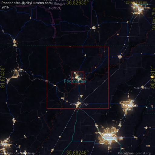
Analysis of Pocahontas night lights 2016
Square area 10x10 km:
 1.92%
1.92%90-99
3.5%80-89
3.32%70-79
3.15%60-69
2.1%50-59
2.62%40-49
3.5%30-39
3.67%20-29
1.4%10-19
13.64%0-9
61.19%Square area 50x50 km:
0.1%90-99
0.2%80-89
0.46%70-79
0.21%60-69
0.35%50-59
0.28%40-49
0.24%30-39
0.41%20-29
0.23%10-19
0.95%0-9
96.56%Clear (daylight) street map image can be seen on geolist.org.
Map coordinates:
36° 49' 34.9" North, 91° 40' 27.7" West
36° 15' 41.3" North, 90° 58' 16.4" West
35° 41' 32.9" North, 90° 16' 5.2" West
Some cities around Pocahontas sort by population:
• Jonesboro
52.4 km =32.6 mi,  152°
152°
• Paragould
48.2 km =30 mi,  117°
117°
• Poplar Bluff
75.5 km =46.9 mi,  43°
43°
• West Plains
94.3 km =58.6 mi,  303°
303°
• Batesville
81.3 km =50.5 mi,  227°
227°
• Kennett
82.1 km =51 mi,  91°
91°
• Newport
78.2 km =48.6 mi,  200°
200°
• Trumann
77.5 km =48.2 mi, 147°
4126923 (p: 6,438)
Sources (retrieved 2019-11-25):
» Earth at Night: Flat Maps 2012, 2016