Wynne night lights from space
Night Light of Wynne (Arkansas) from space (United States) Src. Average luminocity for 10x10km area is 25.6311% and for 50x50km: 3.6641%.
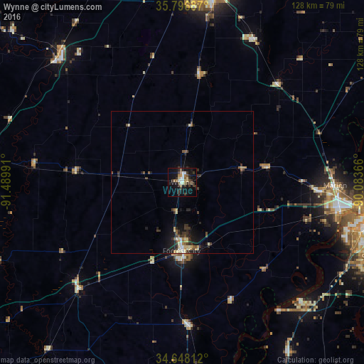
Analysis of Wynne night lights 2016
Square area 10x10 km:
 2.62%
2.62%90-99
4.2%80-89
2.27%70-79
1.75%60-69
3.5%50-59
3.5%40-49
2.97%30-39
10.14%20-29
4.9%10-19
26.22%0-9
37.94%Square area 50x50 km:
0.25%90-99
0.51%80-89
0.53%70-79
0.34%60-69
0.32%50-59
0.58%40-49
0.4%30-39
1.29%20-29
0.91%10-19
2.9%0-9
91.96%Clear (daylight) street map image can be seen on geolist.org.
Map coordinates:
35° 47' 48.7" North, 91° 29' 23.7" West
35° 13' 28.3" North, 90° 47' 12.4" West
34° 38' 53.2" North, 90° 5' 1.2" West
Some cities around Wynne sort by population:
• Memphis
67.6 km =42 mi,  97°
97°
• New South Memphis
68.1 km =42.3 mi, 102°
• Jonesboro
69.1 km =42.9 mi,  6°
6°
• West Memphis
55.4 km =34.4 mi, 99°
• Forrest City
24.1 km =15 mi,  180°
180°
• Marion
53.6 km =33.3 mi,  91°
91°
• Newport
61.6 km =38.3 mi,  313°
313°
• Trumann
56 km =34.8 mi,  26°
26°
4137215 (p: 8,193)
Sources (retrieved 2019-11-25):
» Earth at Night: Flat Maps 2012, 2016