Newport night lights from space
Night Light of Newport (Kentucky) from space (United States) Src. Average luminocity for 10x10km area is 92.0211% and for 50x50km: 56.2696%.
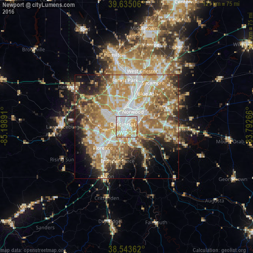
Analysis of Newport night lights 2016
Square area 10x10 km:
 37.82%
90-99
28.9%80-89
15.91%70-79
13.47%60-69
3.9%50-59
0%40-49
0%30-39
0%20-29
0%10-19
0%0-9
0%Square area 50x50 km:
11.26%90-99
12.14%80-89
7.94%70-79
10.28%60-69
10.9%50-59
9.27%40-49
4.93%30-39
4.33%20-29
6.62%10-19
7.84%0-9
14.5%Clear (daylight) street map image can be seen on geolist.org.
Map coordinates:
39° 38' 6.2" North, 85° 11' 56.1" West
39° 5' 29.2" North, 84° 29' 44.8" West
38° 32' 37" North, 83° 47' 33.6" West
Some cities around Newport sort by population:
• Cincinnati
4.3 km =2.7 mi,  337°
337°
• Covington
1.4 km =0.9 mi,  231°
231°
• Fort Thomas
4.6 km =2.9 mi,  113°
113°
• Fort Mitchell
5.7 km =3.5 mi, 231°
• Highland Heights
7.5 km =4.7 mi,  149°
149°
• Bellevue
2.2 km =1.4 mi,  41°
41°
• Fort Wright
5.5 km =3.4 mi,  216°
216°
• Dayton
3.1 km =1.9 mi, 39°
4302529 (p: 15,354)
Sources (retrieved 2019-11-25):
» Earth at Night: Flat Maps 2012, 2016