Highland Heights night lights from space
Night Light of Highland Heights (Kentucky) from space (United States) Src. Average luminocity for 10x10km area is 72.3766% and for 50x50km: 49.543%.
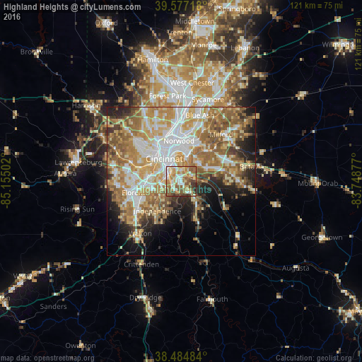
Analysis of Highland Heights night lights 2016
Square area 10x10 km:
 12.18%
90-99
14.61%80-89
15.42%70-79
11.04%60-69
17.21%50-59
15.1%40-49
7.95%30-39
5.03%20-29
1.46%10-19
0%0-9
0%Square area 50x50 km:
9.45%90-99
10.38%80-89
7.02%70-79
9.05%60-69
9.67%50-59
9.03%40-49
4.44%30-39
3.46%20-29
5.87%10-19
8.07%0-9
23.56%Clear (daylight) street map image can be seen on geolist.org.
Map coordinates:
39° 34' 37.8" North, 85° 9' 18.1" West
39° 1' 59.2" North, 84° 27' 6.8" West
38° 29' 5.4" North, 83° 44' 55.6" West
Some cities around Highland Heights sort by population:
• Covington
7.5 km =4.7 mi,  318°
318°
• Fort Thomas
4.7 km =2.9 mi,  5°
5°
• Newport
7.5 km =4.7 mi,  329°
329°
• Fort Mitchell
8.8 km =5.5 mi,  289°
289°
• Taylor Mill
5.5 km =3.4 mi,  224°
224°
• Cold Spring
1.6 km =1 mi,  140°
140°
• Bellevue
8.5 km =5.3 mi,  344°
344°
• Fort Wright
7.4 km =4.6 mi, 286°
4294788 (p: 7,183)
Sources (retrieved 2019-11-25):
» Earth at Night: Flat Maps 2012, 2016