Fort Thomas night lights from space
Night Light of Fort Thomas (Kentucky) from space (United States) Src. Average luminocity for 10x10km area is 81.0747% and for 50x50km: 54.7593%.
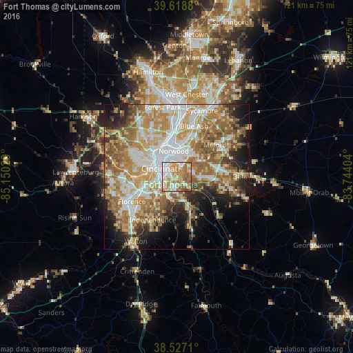
Analysis of Fort Thomas night lights 2016
Square area 10x10 km:
 18.51%
90-99
18.51%80-89
15.91%70-79
17.86%60-69
21.1%50-59
6.66%40-49
1.46%30-39
0%20-29
0%10-19
0%0-9
0%Square area 50x50 km:
10.85%90-99
11.87%80-89
7.61%70-79
9.91%60-69
10.71%50-59
9.33%40-49
4.7%30-39
3.9%20-29
6.37%10-19
8.63%0-9
16.12%Clear (daylight) street map image can be seen on geolist.org.
Map coordinates:
39° 37' 7.7" North, 85° 9' 1" West
39° 4' 30.2" North, 84° 26' 49.8" West
38° 31' 37.6" North, 83° 44' 38.5" West
Some cities around Fort Thomas sort by population:
• Cincinnati
8.2 km =5.1 mi,  314°
314°
• Covington
5.4 km =3.4 mi,  280°
280°
• Newport
4.6 km =2.9 mi,  293°
293°
• Highland Heights
4.7 km =2.9 mi,  185°
185°
• Cold Spring
6 km =3.7 mi,  173°
173°
• Bellevue
4.4 km =2.7 mi,  321°
321°
• Dayton
4.7 km =2.9 mi,  332°
332°
• Turpin Hills
7 km =4.3 mi,  56°
56°
4292071 (p: 16,398)
Sources (retrieved 2019-11-25):
» Earth at Night: Flat Maps 2012, 2016