Fort Wright night lights from space
Night Light of Fort Wright (Kentucky) from space (United States) Src. Average luminocity for 10x10km area is 87.4838% and for 50x50km: 50.2675%.
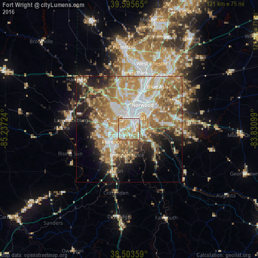
Analysis of Fort Wright night lights 2016
Square area 10x10 km:
 23.7%
23.7%90-99
25.65%80-89
20.78%70-79
21.43%60-69
7.63%50-59
0.81%40-49
0%30-39
0%20-29
0%10-19
0%0-9
0%Square area 50x50 km:
9.93%90-99
10.66%80-89
7.1%70-79
9.09%60-69
10.19%50-59
8.27%40-49
4%30-39
3.58%20-29
5.84%10-19
9.11%0-9
22.22%Clear (daylight) street map image can be seen on geolist.org.
Map coordinates:
39° 35' 44.3" North, 85° 14' 14.1" West
39° 3' 6.2" North, 84° 32' 2.8" West
38° 30' 12.9" North, 83° 49' 51.6" West
Some cities around Fort Wright sort by population:
• Covington
4.2 km =2.6 mi,  31°
31°
• Erlanger
6.9 km =4.3 mi,  235°
235°
• Newport
5.5 km =3.4 mi,  36°
36°
• Edgewood
5.5 km =3.4 mi,  228°
228°
• Elsmere
7.5 km =4.7 mi, 234°
• Villa Hills
5.2 km =3.2 mi,  284°
284°
• Highland Heights
7.4 km =4.6 mi,  106°
106°
• Taylor Mill
6.9 km =4.3 mi,  151°
151°
4292072 (p: 5,781)
Sources (retrieved 2019-11-25):
» Earth at Night: Flat Maps 2012, 2016