Lake Carmel night lights from space
Night Light of Lake Carmel (New York) from space (United States) Src. Average luminocity for 10x10km area is 14.9762% and for 50x50km: 19.1849%.
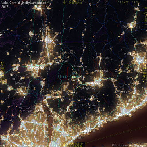
Analysis of Lake Carmel night lights 2016
Square area 10x10 km:
 0%
0%90-99
0%80-89
2.72%70-79
3.23%60-69
2.04%50-59
0.85%40-49
1.87%30-39
5.1%20-29
6.8%10-19
13.44%0-9
63.95%Square area 50x50 km:
1.23%90-99
1.8%80-89
2.78%70-79
2.62%60-69
2.67%50-59
2.59%40-49
3.59%30-39
4.82%20-29
7.68%10-19
16.87%0-9
53.37%Clear (daylight) street map image can be seen on geolist.org.
Map coordinates:
41° 59' 10.5" North, 74° 22' 26.7" West
41° 27' 41.3" North, 73° 40' 15.5" West
40° 55' 56.7" North, 72° 58' 4.2" West
Some cities around Lake Carmel sort by population:
• Danbury
19.5 km =12.1 mi,  112°
112°
• Jefferson Valley-Yorktown
19.3 km =12 mi,  214°
214°
• New Fairfield
15.4 km =9.6 mi,  87°
87°
• Bethel
23.7 km =14.7 mi,  115°
115°
• Mahopac
11.2 km =7 mi, 207°
• Ridgefield
24.7 km =15.3 mi,  144°
144°
• Carmel Hamlet
5.3 km =3.3 mi,  192°
192°
• Myers Corner
23.3 km =14.5 mi,  313°
313°
5123777 (p: 8,282)
Sources (retrieved 2019-11-25):
» Earth at Night: Flat Maps 2012, 2016