Bethel night lights from space
Night Light of Bethel (Connecticut) from space (United States) Src. Average luminocity for 10x10km area is 39.6241% and for 50x50km: 20.6504%.
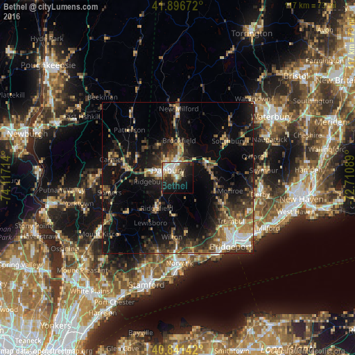
Analysis of Bethel night lights 2016
Square area 10x10 km:
 7.14%
7.14%90-99
10.03%80-89
5.27%70-79
1.36%60-69
4.76%50-59
3.4%40-49
6.12%30-39
6.12%20-29
12.59%10-19
27.21%0-9
15.99%Square area 50x50 km:
1.93%90-99
2.17%80-89
2.5%70-79
2.52%60-69
3.26%50-59
2.97%40-49
3.79%30-39
4.59%20-29
6.92%10-19
15.9%0-9
53.45%Clear (daylight) street map image can be seen on geolist.org.
Map coordinates:
41° 53' 48.2" North, 74° 7' 1.7" West
41° 22' 16.4" North, 73° 24' 50.4" West
40° 50' 29.1" North, 72° 42' 39.2" West
Some cities around Bethel sort by population:
• Danbury
4.2 km =2.6 mi,  308°
308°
• Trumbull
22.8 km =14.2 mi,  128°
128°
• Southbury
20.8 km =12.9 mi,  53°
53°
• Wilton
19.7 km =12.2 mi,  185°
185°
• New Fairfield
12.2 km =7.6 mi,  330°
330°
• Ridgefield
12.2 km =7.6 mi,  215°
215°
• Easton
16.4 km =10.2 mi,  143°
143°
• Pound Ridge
22.5 km =14 mi, 216°
5282297 (p: 9,549)
Sources (retrieved 2019-11-25):
» Earth at Night: Flat Maps 2012, 2016