New Martinsville night lights from space
Night Light of New Martinsville (West Virginia) from space (United States) Src. Average luminocity for 10x10km area is 14.4481% and for 50x50km: 3.5644%.
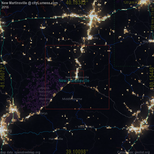
Analysis of New Martinsville night lights 2016
Square area 10x10 km:
 2.92%
2.92%90-99
1.62%80-89
1.79%70-79
0.16%60-69
0.97%50-59
2.27%40-49
2.11%30-39
2.27%20-29
1.62%10-19
9.74%0-9
74.51%Square area 50x50 km:
0.32%90-99
0.43%80-89
0.48%70-79
0.28%60-69
0.32%50-59
0.76%40-49
0.58%30-39
0.52%20-29
0.76%10-19
2.16%0-9
93.38%Clear (daylight) street map image can be seen on geolist.org.
Map coordinates:
40° 11' 1.8" North, 81° 33' 38.6" West
39° 38' 40.3" North, 80° 51' 27.4" West
39° 6' 3.5" North, 80° 9' 16.1" West
Some cities around New Martinsville sort by population:
• Wheeling
48.1 km =29.9 mi,  14°
14°
• Fairmont
63.8 km =39.6 mi,  106°
106°
• Clarksburg
59.8 km =37.2 mi,  132°
132°
• Marietta
57.2 km =35.5 mi,  243°
243°
• Moundsville
32.2 km =20 mi,  17°
17°
• Bridgeport
65.2 km =40.5 mi, 127°
• Martins Ferry
51.5 km =32 mi, 12°
• Saint Clairsville
48.6 km =30.2 mi,  355°
355°
4816520 (p: 5,218)
Sources (retrieved 2019-11-25):
» Earth at Night: Flat Maps 2012, 2016