Moundsville night lights from space
Night Light of Moundsville (West Virginia) from space (United States) Src. Average luminocity for 10x10km area is 28.5476% and for 50x50km: 11.7541%.
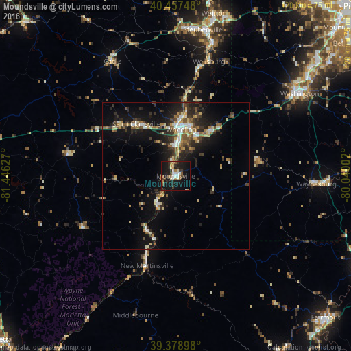
Analysis of Moundsville night lights 2016
Square area 10x10 km:
 3.57%
3.57%90-99
4.93%80-89
1.7%70-79
2.04%60-69
5.44%50-59
3.06%40-49
3.57%30-39
3.74%20-29
8.84%10-19
43.71%0-9
19.39%Square area 50x50 km:
1.18%90-99
1.74%80-89
1.37%70-79
1.05%60-69
1.48%50-59
1.68%40-49
1.71%30-39
2.28%20-29
4.09%10-19
10%0-9
73.43%Clear (daylight) street map image can be seen on geolist.org.
Map coordinates:
40° 27' 26.9" North, 81° 26' 46.6" West
39° 55' 13.3" North, 80° 44' 35.3" West
39° 22' 44.3" North, 80° 2' 24.1" West
Some cities around Moundsville sort by population:
• Wheeling
16.1 km =10 mi,  6°
6°
• Weirton Heights
57 km =35.4 mi,  17°
17°
• Weirton
57 km =35.4 mi, 13°
• Steubenville
50.8 km =31.6 mi, 10°
• Washington
50.8 km =31.6 mi,  56°
56°
• Martins Ferry
19.6 km =12.2 mi,  4°
4°
• New Martinsville
32.2 km =20 mi,  197°
197°
• Saint Clairsville
22.3 km =13.9 mi,  323°
323°
4815462 (p: 8,710)
Sources (retrieved 2019-11-25):
» Earth at Night: Flat Maps 2012, 2016