Martins Ferry night lights from space
Night Light of Martins Ferry (Ohio) from space (United States) Src. Average luminocity for 10x10km area is 49.6364% and for 50x50km: 12.8508%.
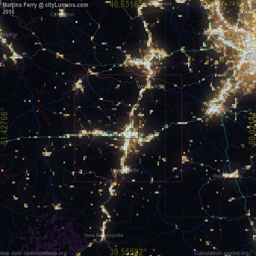
Analysis of Martins Ferry night lights 2016
Square area 10x10 km:
 9.25%
9.25%90-99
12.01%80-89
5.52%70-79
4.87%60-69
4.87%50-59
8.28%40-49
5.03%30-39
9.9%20-29
18.51%10-19
17.05%0-9
4.71%Square area 50x50 km:
1.03%90-99
1.92%80-89
1.49%70-79
1.21%60-69
1.56%50-59
1.95%40-49
2%30-39
2.46%20-29
4.53%10-19
11.3%0-9
70.55%Clear (daylight) street map image can be seen on geolist.org.
Map coordinates:
40° 37' 53.9" North, 81° 25' 39.6" West
40° 5' 45.3" North, 80° 43' 28.3" West
39° 33' 21.3" North, 80° 1' 17.1" West
Some cities around Martins Ferry sort by population:
• Wheeling
3.6 km =2.2 mi,  175°
175°
• Weirton Heights
38.1 km =23.7 mi,  24°
24°
• Weirton
37.7 km =23.4 mi, 17°
• Steubenville
31.4 km =19.5 mi,  14°
14°
• Washington
41.6 km =25.8 mi,  77°
77°
• Canonsburg
49.3 km =30.6 mi,  67°
67°
• Moundsville
19.6 km =12.2 mi, 184°
• Saint Clairsville
15 km =9.3 mi,  263°
263°
5162044 (p: 6,786)
Sources (retrieved 2019-11-25):
» Earth at Night: Flat Maps 2012, 2016