New Ipswich night lights from space
Night Light of New Ipswich (New Hampshire) from space (United States) Src. Average luminocity for 10x10km area is 0.8864% and for 50x50km: 7.5567%.
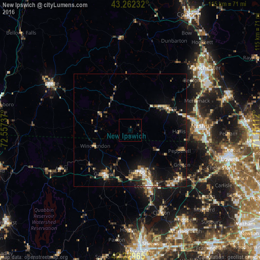
Analysis of New Ipswich night lights 2016
Square area 10x10 km:
 0%
0%90-99
0%80-89
0%70-79
0%60-69
0%50-59
0.61%40-49
0.61%30-39
0%20-29
0.61%10-19
0.61%0-9
97.58%Square area 50x50 km:
0.68%90-99
1.01%80-89
0.98%70-79
0.69%60-69
1.09%50-59
1.3%40-49
1.12%30-39
1.02%20-29
1.89%10-19
5.89%0-9
84.33%Clear (daylight) street map image can be seen on geolist.org.
Map coordinates:
43° 15' 44.4" North, 72° 33' 26.5" West
42° 44' 53.3" North, 71° 51' 15.3" West
42° 13' 46.7" North, 71° 9' 4" West
Some cities around New Ipswich sort by population:
• Leominster
26 km =16.2 mi,  162°
162°
• Fitchburg
18.8 km =11.7 mi,  166°
166°
• Gardner
22.6 km =14 mi,  211°
211°
• Milford
19.4 km =12.1 mi,  59°
59°
• Hollis
21.4 km =13.3 mi,  91°
91°
• Westminster
23 km =14.3 mi,  191°
191°
• Rindge
12.7 km =7.9 mi,  271°
271°
• Ashburnham
13.2 km =8.2 mi,  199°
199°
5090183 (p: 5,283)
Sources (retrieved 2019-11-25):
» Earth at Night: Flat Maps 2012, 2016