Hollis night lights from space
Night Light of Hollis (New Hampshire) from space (United States) Src. Average luminocity for 10x10km area is 8.5242% and for 50x50km: 21.7987%.
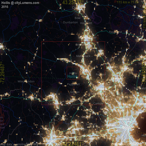
Analysis of Hollis night lights 2016
Square area 10x10 km:
 0%
0%90-99
0.61%80-89
0%70-79
0.45%60-69
0.15%50-59
1.21%40-49
0%30-39
0.91%20-29
10.15%10-19
16.67%0-9
69.85%Square area 50x50 km:
2.55%90-99
3.38%80-89
2.41%70-79
2.56%60-69
3.1%50-59
3.58%40-49
3.5%30-39
3.61%20-29
7.73%10-19
17.31%0-9
50.27%Clear (daylight) street map image can be seen on geolist.org.
Map coordinates:
43° 15' 26.5" North, 72° 17' 41.5" West
42° 44' 35.3" North, 71° 35' 30.3" West
42° 13' 28.6" North, 70° 53' 19" West
Some cities around Hollis sort by population:
• Nashua
10.4 km =6.5 mi,  76°
76°
• Merrimack
15.8 km =9.8 mi,  30°
30°
• Pelham
21.8 km =13.5 mi,  92°
92°
• Tyngsboro
15.5 km =9.6 mi,  118°
118°
• Milford
11.3 km =7 mi,  335°
335°
• Litchfield
14.5 km =9 mi,  39°
39°
• Hudson
12.6 km =7.8 mi, 79°
• New Ipswich
21.4 km =13.3 mi,  271°
271°
5087559 (p: 7,711)
Sources (retrieved 2019-11-25):
» Earth at Night: Flat Maps 2012, 2016