Rindge night lights from space
Night Light of Rindge (New Hampshire) from space (United States) Src. Average luminocity for 10x10km area is 2.5348% and for 50x50km: 5.8669%.
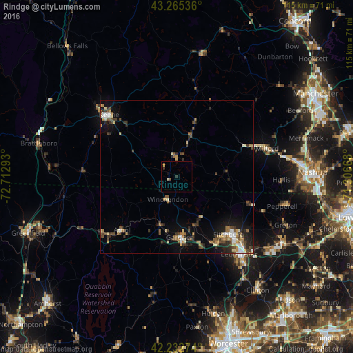
Analysis of Rindge night lights 2016
Square area 10x10 km:
 0%
0%90-99
0.61%80-89
0.61%70-79
0%60-69
0%50-59
0.61%40-49
0%30-39
0.61%20-29
0.61%10-19
0.61%0-9
96.36%Square area 50x50 km:
0.59%90-99
0.75%80-89
0.83%70-79
0.61%60-69
0.76%50-59
0.91%40-49
1.16%30-39
1.02%20-29
1.41%10-19
3.22%0-9
88.74%Clear (daylight) street map image can be seen on geolist.org.
Map coordinates:
43° 15' 55.3" North, 72° 42' 46.5" West
42° 45' 4.3" North, 72° 0' 35.3" West
42° 13' 57.9" North, 71° 18' 24" West
Some cities around Rindge sort by population:
• Fitchburg
25.2 km =15.7 mi,  137°
137°
• Gardner
19.6 km =12.2 mi,  177°
177°
• Athol
24.8 km =15.4 mi,  225°
225°
• Swanzey
25.8 km =16 mi,  300°
300°
• Westminster
24.2 km =15 mi,  160°
160°
• Templeton
22.3 km =13.9 mi,  192°
192°
• Ashburnham
15.3 km =9.5 mi,  146°
146°
• New Ipswich
12.7 km =7.9 mi,  91°
91°
5091744 (p: 6,049)
Sources (retrieved 2019-11-25):
» Earth at Night: Flat Maps 2012, 2016