New Baltimore night lights from space
Night Light of New Baltimore (Michigan) from space (United States) Src. Average luminocity for 10x10km area is 32.0136% and for 50x50km: 25.5877%.
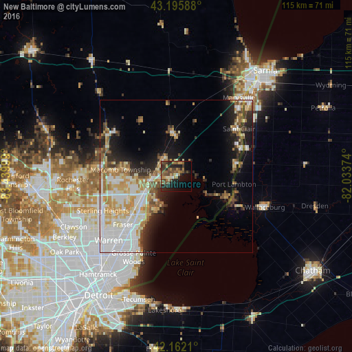
Analysis of New Baltimore night lights 2016
Square area 10x10 km:
 0.45%
0.45%90-99
3.33%80-89
3.33%70-79
4.39%60-69
6.97%50-59
8.79%40-49
9.39%30-39
5.91%20-29
11.67%10-19
18.64%0-9
27.12%Square area 50x50 km:
6.29%90-99
5.41%80-89
3.33%70-79
3.6%60-69
3.2%50-59
2.6%40-49
2.38%30-39
2.26%20-29
4.87%10-19
8.04%0-9
58.02%Clear (daylight) street map image can be seen on geolist.org.
Map coordinates:
43° 11' 45.2" North, 83° 26' 24" West
42° 40' 52.1" North, 82° 44' 12.7" West
42° 9' 43.6" North, 82° 2' 1.5" West
Some cities around New Baltimore sort by population:
• Clinton Township
18.3 km =11.4 mi,  235°
235°
• Shelby
24.2 km =15 mi,  267°
267°
• Saint Clair Shores
24 km =14.9 mi,  211°
211°
• Roseville
26.2 km =16.3 mi,  218°
218°
• Mount Clemens
14.8 km =9.2 mi,  231°
231°
• Fraser
23.5 km =14.6 mi, 227°
• Richmond
14.3 km =8.9 mi,  353°
353°
• Saint Clair
25.7 km =16 mi,  52°
52°
5003369 (p: 12,354)
Sources (retrieved 2019-11-25):
» Earth at Night: Flat Maps 2012, 2016