Richmond night lights from space
Night Light of Richmond (Michigan) from space (United States) Src. Average luminocity for 10x10km area is 12.1667% and for 50x50km: 20.762%.
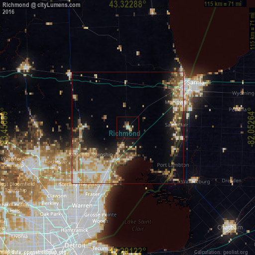
Analysis of Richmond night lights 2016
Square area 10x10 km:
 1.36%
1.36%90-99
0.91%80-89
1.36%70-79
1.82%60-69
1.52%50-59
1.06%40-49
2.27%30-39
0.45%20-29
1.97%10-19
8.03%0-9
79.24%Square area 50x50 km:
2.63%90-99
3.61%80-89
3.3%70-79
3.17%60-69
3.6%50-59
3.4%40-49
2.98%30-39
2.48%20-29
4.6%10-19
7.73%0-9
62.51%Clear (daylight) street map image can be seen on geolist.org.
Map coordinates:
43° 19' 22.4" North, 83° 27' 32" West
42° 48' 33.1" North, 82° 45' 20.7" West
42° 17' 28.4" North, 82° 3' 9.5" West
Some cities around Richmond sort by population:
• Clinton Township
28.1 km =17.5 mi,  208°
208°
• Shelby
27.4 km =17 mi,  235°
235°
• Port Huron
32.4 km =20.1 mi,  56°
56°
• Mount Clemens
25.6 km =15.9 mi,  202°
202°
• New Baltimore
14.3 km =8.9 mi,  173°
173°
• Marysville
24.7 km =15.3 mi, 62°
• Corunna, CA
27.6 km =17.1 mi,  72°
72°
• Saint Clair
22 km =13.7 mi,  86°
86°
5007141 (p: 5,864)
Sources (retrieved 2019-11-25):
» Earth at Night: Flat Maps 2012, 2016