Saint Clair night lights from space
Night Light of Saint Clair (Michigan) from space (United States) Src. Average luminocity for 10x10km area is 31.5045% and for 50x50km: 14.1997%.
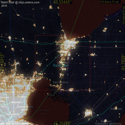
Analysis of Saint Clair night lights 2016
Square area 10x10 km:
 1.97%
1.97%90-99
4.7%80-89
3.79%70-79
2.12%60-69
4.7%50-59
4.55%40-49
3.48%30-39
8.33%20-29
18.03%10-19
35.61%0-9
12.73%Square area 50x50 km:
1.93%90-99
2.44%80-89
1.71%70-79
1.19%60-69
2.23%50-59
2.4%40-49
2.29%30-39
2.11%20-29
4.32%10-19
7.77%0-9
71.6%Clear (daylight) street map image can be seen on geolist.org.
Map coordinates:
43° 20' 4" North, 83° 11' 20.9" West
42° 49' 15.1" North, 82° 29' 9.7" West
42° 18' 10.8" North, 81° 46' 58.4" West
Some cities around Saint Clair sort by population:
• Sarnia, CA
18.8 km =11.7 mi,  20°
20°
• Port Huron
17.4 km =10.8 mi, 16°
• New Baltimore
25.7 km =16 mi,  232°
232°
• Marysville
10.2 km =6.3 mi,  359°
359°
• Camlachie, CA
35.6 km =22.1 mi,  47°
47°
• Richmond
22 km =13.7 mi,  266°
266°
• Corunna, CA
8.2 km =5.1 mi,  31°
31°
• Petrolia, CA
27.9 km =17.3 mi,  79°
79°
5010977 (p: 5,485)
Sources (retrieved 2019-11-25):
» Earth at Night: Flat Maps 2012, 2016