Bexley night lights from space
Night Light of Bexley (Ohio) from space (United States) Src. Average luminocity for 10x10km area is 99.6633% and for 50x50km: 54.4514%.
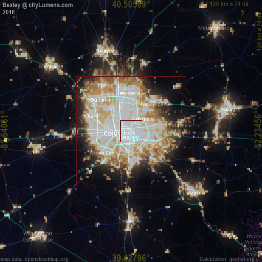
Analysis of Bexley night lights 2016
Square area 10x10 km:
 79.76%
90-99
19.9%80-89
0.34%70-79
0%60-69
0%50-59
0%40-49
0%30-39
0%20-29
0%10-19
0%0-9
0%Square area 50x50 km:
16.71%90-99
14.76%80-89
5.72%70-79
6.56%60-69
6.46%50-59
4.9%40-49
3.69%30-39
4.11%20-29
6.62%10-19
10.4%0-9
20.08%Clear (daylight) street map image can be seen on geolist.org.
Map coordinates:
40° 30' 20.5" North, 83° 38' 26.9" West
39° 58' 8.2" North, 82° 56' 15.6" West
39° 25' 40.7" North, 82° 14' 4.4" West
Some cities around Bexley sort by population:
• Columbus
5.3 km =3.3 mi,  260°
260°
• Reynoldsburg
10.8 km =6.7 mi,  98°
98°
• Upper Arlington
11 km =6.8 mi,  284°
284°
• Gahanna
7.5 km =4.7 mi,  41°
41°
• Whitehall
4.5 km =2.8 mi,  93°
93°
• Blacklick Estates
9.5 km =5.9 mi,  138°
138°
• Grandview Heights
8.9 km =5.5 mi, 277°
• Groveport
11.1 km =6.9 mi,  155°
155°
4506487 (p: 13,654)
Sources (retrieved 2019-11-25):
» Earth at Night: Flat Maps 2012, 2016