Mount Vernon night lights from space
Night Light of Mount Vernon (Ohio) from space (United States) Src. Average luminocity for 10x10km area is 36.3929% and for 50x50km: 2.7272%.
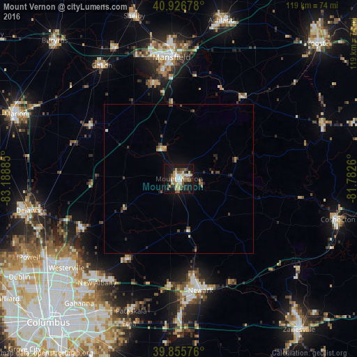
Analysis of Mount Vernon night lights 2016
Square area 10x10 km:
 4.93%
4.93%90-99
5.78%80-89
6.12%70-79
3.57%60-69
4.76%50-59
5.95%40-49
4.93%30-39
5.27%20-29
6.97%10-19
36.56%0-9
15.14%Square area 50x50 km:
0.2%90-99
0.32%80-89
0.34%70-79
0.24%60-69
0.39%50-59
0.44%40-49
0.51%30-39
0.4%20-29
0.7%10-19
2.01%0-9
94.43%Clear (daylight) street map image can be seen on geolist.org.
Map coordinates:
40° 55' 36.4" North, 83° 11' 19.9" West
40° 23' 36.2" North, 82° 29' 8.6" West
39° 51' 20.7" North, 81° 46' 57.4" West
Some cities around Mount Vernon sort by population:
• Newark
38 km =23.6 mi,  169°
169°
• Mansfield
40.7 km =25.3 mi,  356°
356°
• Heath
41.4 km =25.7 mi,  175°
175°
• New Albany
44.2 km =27.5 mi,  218°
218°
• Ontario
41.7 km =25.9 mi,  347°
347°
• Granville
36.3 km =22.6 mi, 184°
• Sunbury
35.8 km =22.2 mi,  242°
242°
• Apple Valley
12.3 km =7.6 mi,  65°
65°
5163799 (p: 16,742)
Sources (retrieved 2019-11-25):
» Earth at Night: Flat Maps 2012, 2016