Apple Valley night lights from space
Night Light of Apple Valley (Ohio) from space (United States) Src. Average luminocity for 10x10km area is 2.8554% and for 50x50km: 3.0249%.
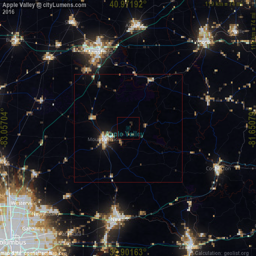
Analysis of Apple Valley night lights 2016
Square area 10x10 km:
 0%
0%90-99
0%80-89
0%70-79
0%60-69
0.68%50-59
0%40-49
1.36%30-39
0.34%20-29
3.06%10-19
0.68%0-9
93.88%Square area 50x50 km:
0.22%90-99
0.34%80-89
0.46%70-79
0.27%60-69
0.39%50-59
0.54%40-49
0.53%30-39
0.4%20-29
0.68%10-19
2.19%0-9
93.98%Clear (daylight) street map image can be seen on geolist.org.
Map coordinates:
40° 58' 18.9" North, 83° 3' 25.3" West
40° 26' 20" North, 82° 21' 14.1" West
39° 54' 5.9" North, 81° 39' 2.8" West
Some cities around Apple Valley sort by population:
• Newark
42.5 km =26.4 mi,  185°
185°
• Mansfield
38.1 km =23.7 mi,  338°
338°
• Ashland
47.9 km =29.8 mi,  3°
3°
• Mount Vernon
12.3 km =7.6 mi,  245°
245°
• Coshocton
45.8 km =28.5 mi,  113°
113°
• Heath
46.9 km =29.1 mi, 189°
• Ontario
40.8 km =25.4 mi,  330°
330°
• Granville
43.6 km =27.1 mi,  198°
198°
8480059 (p: 5,058)
Sources (retrieved 2019-11-25):
» Earth at Night: Flat Maps 2012, 2016