Steubenville night lights from space
Night Light of Steubenville (Ohio) from space (United States) Src. Average luminocity for 10x10km area is 57.4915% and for 50x50km: 10.0325%.
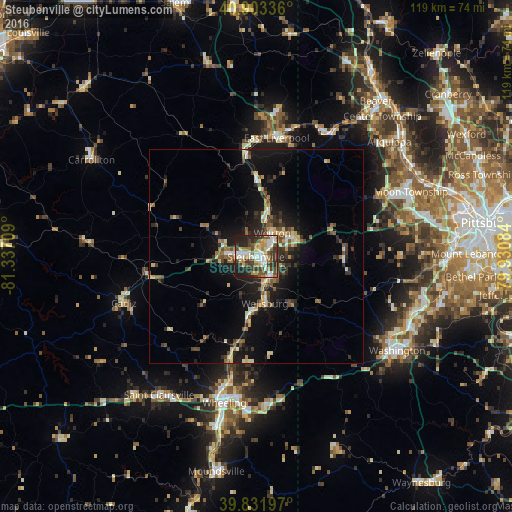
Analysis of Steubenville night lights 2016
Square area 10x10 km:
 11.22%
90-99
12.07%80-89
6.97%70-79
7.48%60-69
7.48%50-59
7.14%40-49
9.01%30-39
16.5%20-29
16.16%10-19
5.95%0-9
0%Square area 50x50 km:
0.73%90-99
1.37%80-89
1.2%70-79
0.98%60-69
1.46%50-59
1.55%40-49
1.47%30-39
2.17%20-29
3.24%10-19
8.08%0-9
77.74%Clear (daylight) street map image can be seen on geolist.org.
Map coordinates:
40° 54' 12.1" North, 81° 20' 13.5" West
40° 22' 11.2" North, 80° 38' 2.3" West
39° 49' 55.1" North, 79° 55' 51" West
Some cities around Steubenville sort by population:
• Wheeling
34.8 km =21.6 mi,  192°
192°
• Weirton Heights
9.1 km =5.7 mi,  61°
61°
• Weirton
6.6 km =4.1 mi,  34°
34°
• Washington
39.5 km =24.5 mi,  123°
123°
• Carnot-Moon
38.9 km =24.2 mi, 64°
• East Liverpool
28.1 km =17.5 mi,  9°
9°
• Martins Ferry
31.4 km =19.5 mi, 194°
• Saint Clairsville
39.3 km =24.4 mi,  215°
215°
5173048 (p: 18,219)
Sources (retrieved 2019-11-25):
» Earth at Night: Flat Maps 2012, 2016