Milford night lights from space
Night Light of Milford (Delaware) from space (United States) Src. Average luminocity for 10x10km area is 35.415% and for 50x50km: 11.2249%.
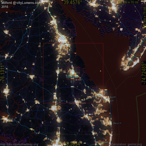
Analysis of Milford night lights 2016
Square area 10x10 km:
 3.91%
3.91%90-99
4.25%80-89
4.08%70-79
6.12%60-69
6.12%50-59
5.78%40-49
3.23%30-39
5.78%20-29
10.54%10-19
39.8%0-9
10.37%Square area 50x50 km:
0.76%90-99
0.82%80-89
1.43%70-79
1.99%60-69
1.77%50-59
1.78%40-49
1.36%30-39
2.87%20-29
3.14%10-19
9.29%0-9
74.78%Clear (daylight) street map image can be seen on geolist.org.
Map coordinates:
39° 27' 27.4" North, 76° 7' 52" West
38° 54' 45.4" North, 75° 25' 40.7" West
38° 21' 48.2" North, 74° 43' 29.5" West
Some cities around Milford sort by population:
• Dover
28.5 km =17.7 mi,  343°
343°
• Easton
58.2 km =36.2 mi,  254°
254°
• Smyrna
45.7 km =28.4 mi, 340°
• Villas
44.2 km =27.5 mi,  73°
73°
• Seaford
34.1 km =21.2 mi,  207°
207°
• Georgetown
25 km =15.5 mi,  171°
171°
• Cape May Court House
55.5 km =34.5 mi, 70°
• Wildwood
53.7 km =33.4 mi,  80°
80°
4143658 (p: 10,252)
Sources (retrieved 2019-11-25):
» Earth at Night: Flat Maps 2012, 2016