Villas night lights from space
Night Light of Villas (New Jersey) from space (United States) Src. Average luminocity for 10x10km area is 29.0958% and for 50x50km: 7.6138%.
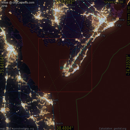
Analysis of Villas night lights 2016
Square area 10x10 km:
 0.49%
0.49%90-99
2.11%80-89
5.19%70-79
7.14%60-69
4.87%50-59
4.87%40-49
5.68%30-39
6.33%20-29
9.09%10-19
21.27%0-9
32.95%Square area 50x50 km:
0.49%90-99
0.73%80-89
0.97%70-79
1.42%60-69
0.89%50-59
1.09%40-49
1.38%30-39
1.06%20-29
2.04%10-19
9.1%0-9
80.83%Clear (daylight) street map image can be seen on geolist.org.
Map coordinates:
39° 34' 22.2" North, 75° 38' 29.9" West
39° 1' 43.4" North, 74° 56' 18.6" West
38° 28' 49.4" North, 74° 14' 7.4" West
Some cities around Villas sort by population:
• South Vineland
47 km =29.2 mi,  350°
350°
• Millville
42.4 km =26.3 mi, 348°
• Ocean City
41.8 km =26 mi,  48°
48°
• Somers Point
43.7 km =27.2 mi,  42°
42°
• Milford
44.2 km =27.5 mi,  253°
253°
• Linwood
46.7 km =29 mi, 42°
• Cape May Court House
11.6 km =7.2 mi,  58°
58°
• Wildwood
11.4 km =7.1 mi,  111°
111°
4504616 (p: 9,483)
Sources (retrieved 2019-11-25):
» Earth at Night: Flat Maps 2012, 2016