Easton night lights from space
Night Light of Easton (Maryland) from space (United States) Src. Average luminocity for 10x10km area is 28.7891% and for 50x50km: 5.2931%.
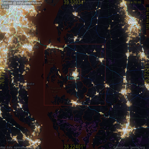
Analysis of Easton night lights 2016
Square area 10x10 km:
 4.25%
4.25%90-99
2.55%80-89
5.95%70-79
5.27%60-69
2.38%50-59
4.25%40-49
3.57%30-39
3.23%20-29
2.89%10-19
32.48%0-9
33.16%Square area 50x50 km:
0.37%90-99
0.39%80-89
0.97%70-79
0.89%60-69
0.64%50-59
0.86%40-49
0.84%30-39
1.08%20-29
0.66%10-19
3.21%0-9
90.09%Clear (daylight) street map image can be seen on geolist.org.
Map coordinates:
39° 19' 13.2" North, 76° 46' 46.1" West
38° 46' 27.4" North, 76° 4' 34.8" West
38° 13' 26.4" North, 75° 22' 23.6" West
Some cities around Easton sort by population:
• Annapolis
42.5 km =26.4 mi,  302°
302°
• Cambridge
23.5 km =14.6 mi,  180°
180°
• Mayo
39.8 km =24.7 mi,  288°
288°
• Seaford
43 km =26.7 mi,  110°
110°
• Stevensville
30.8 km =19.1 mi,  318°
318°
• Chesapeake Beach
40.9 km =25.4 mi,  256°
256°
• Shady Side
38.5 km =23.9 mi,  281°
281°
• Robinwood
42.9 km =26.7 mi, 297°
4353962 (p: 16,617)
Sources (retrieved 2019-11-25):
» Earth at Night: Flat Maps 2012, 2016