Seaford night lights from space
Night Light of Seaford (Delaware) from space (United States) Src. Average luminocity for 10x10km area is 37.8864% and for 50x50km: 7.5829%.
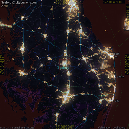
Analysis of Seaford night lights 2016
Square area 10x10 km:
 4.06%
4.06%90-99
7.47%80-89
3.9%70-79
4.55%60-69
6.17%50-59
4.87%40-49
5.84%30-39
6.01%20-29
14.77%10-19
31.66%0-9
10.71%Square area 50x50 km:
0.4%90-99
0.71%80-89
1.04%70-79
0.92%60-69
0.99%50-59
0.92%40-49
0.97%30-39
1.83%20-29
2.24%10-19
7.26%0-9
82.72%Clear (daylight) street map image can be seen on geolist.org.
Map coordinates:
39° 11' 17.9" North, 76° 18' 51" West
38° 38' 28.4" North, 75° 36' 39.7" West
38° 5' 23.8" North, 74° 54' 28.5" West
Some cities around Seaford sort by population:
• Salisbury
31.2 km =19.4 mi,  178°
178°
• Easton
43 km =26.7 mi,  290°
290°
• Cambridge
41.6 km =25.8 mi,  257°
257°
• Ocean Pines
48.1 km =29.9 mi,  124°
124°
• Milford
34.1 km =21.2 mi,  27°
27°
• Ocean City
57 km =35.4 mi,  126°
126°
• Georgetown
20.3 km =12.6 mi,  74°
74°
• Fruitland
35.5 km =22.1 mi, 181°
4144600 (p: 7,586)
Sources (retrieved 2019-11-25):
» Earth at Night: Flat Maps 2012, 2016