Cape May Court House night lights from space
Night Light of Cape May Court House (New Jersey) from space (United States) Src. Average luminocity for 10x10km area is 28.0455% and for 50x50km: 9.2579%.
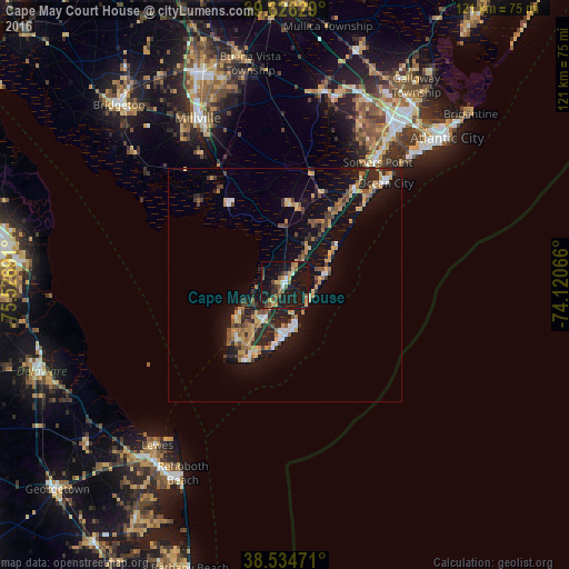
Analysis of Cape May Court House night lights 2016
Square area 10x10 km:
 1.3%
1.3%90-99
1.95%80-89
4.22%70-79
4.06%60-69
2.76%50-59
6.82%40-49
4.38%30-39
3.9%20-29
4.87%10-19
55.03%0-9
10.71%Square area 50x50 km:
0.59%90-99
0.83%80-89
1.22%70-79
1.74%60-69
1.19%50-59
1.2%40-49
1.61%30-39
1.34%20-29
2.66%10-19
10.77%0-9
76.87%Clear (daylight) street map image can be seen on geolist.org.
Map coordinates:
39° 37' 34.6" North, 75° 31' 36.9" West
39° 4' 57.4" North, 74° 49' 25.6" West
38° 32' 5" North, 74° 7' 14.4" West
Some cities around Cape May Court House sort by population:
• Millville
40.1 km =24.9 mi,  332°
332°
• Ocean City
30.5 km =19 mi,  44°
44°
• Somers Point
32.8 km =20.4 mi, 37°
• Villas
11.6 km =7.2 mi,  238°
238°
• Northfield
39.7 km =24.7 mi, 36°
• Linwood
35.7 km =22.2 mi, 36°
• Margate City
38.8 km =24.1 mi,  45°
45°
• Wildwood
10.1 km =6.3 mi,  175°
175°
4501057 (p: 5,338)
Sources (retrieved 2019-11-25):
» Earth at Night: Flat Maps 2012, 2016