Miami night lights from space
Night Light of Miami (Oklahoma) from space (United States) Src. Average luminocity for 10x10km area is 35.026% and for 50x50km: 5.1397%.
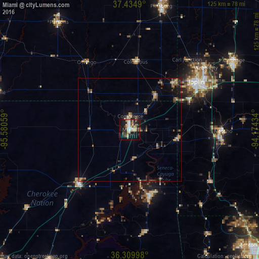
Analysis of Miami night lights 2016
Square area 10x10 km:
 3.9%
3.9%90-99
5.03%80-89
7.63%70-79
3.9%60-69
4.55%50-59
4.87%40-49
3.08%30-39
4.71%20-29
10.39%10-19
32.47%0-9
19.48%Square area 50x50 km:
0.21%90-99
0.37%80-89
0.73%70-79
0.76%60-69
0.75%50-59
0.91%40-49
0.8%30-39
1.41%20-29
1.15%10-19
3.4%0-9
89.51%Clear (daylight) street map image can be seen on geolist.org.
Map coordinates:
37° 26' 5.6" North, 95° 34' 50.1" West
36° 52' 28.2" North, 94° 52' 38.9" West
36° 18' 35.9" North, 94° 10' 27.6" West
Some cities around Miami sort by population:
• Joplin
39.9 km =24.8 mi,  54°
54°
• Pittsburg
61.6 km =38.3 mi,  14°
14°
• Carthage
60.5 km =37.6 mi,  56°
56°
• Neosho
45.3 km =28.1 mi,  90°
90°
• Webb City
47.6 km =29.6 mi, 50°
• Carl Junction
43.5 km =27 mi,  39°
39°
• Grove
32.7 km =20.3 mi,  162°
162°
• Vinita
36 km =22.4 mi,  223°
223°
4542692 (p: 13,611)
Sources (retrieved 2019-11-25):
» Earth at Night: Flat Maps 2012, 2016