Carthage night lights from space
Night Light of Carthage (Missouri) from space (United States) Src. Average luminocity for 10x10km area is 36.5136% and for 50x50km: 10.5046%.
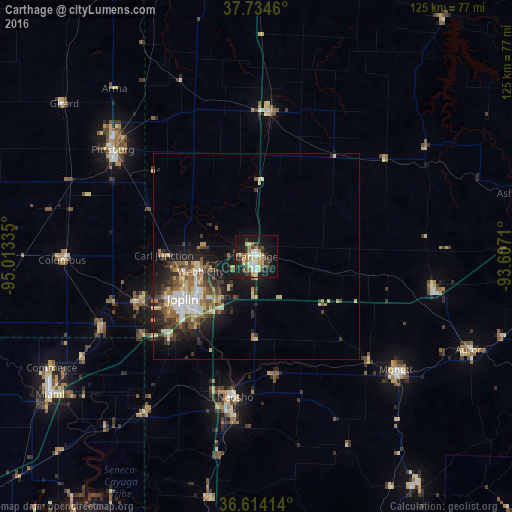
Analysis of Carthage night lights 2016
Square area 10x10 km:
 4.76%
4.76%90-99
4.08%80-89
8.16%70-79
4.93%60-69
4.25%50-59
4.08%40-49
4.42%30-39
9.86%20-29
6.97%10-19
29.93%0-9
18.54%Square area 50x50 km:
1.29%90-99
1.57%80-89
1.59%70-79
1.2%60-69
1.42%50-59
1.77%40-49
1.31%30-39
2.29%20-29
2.97%10-19
6.8%0-9
77.8%Clear (daylight) street map image can be seen on geolist.org.
Map coordinates:
37° 44' 4.6" North, 95° 0' 48.1" West
37° 10' 35.2" North, 94° 18' 36.8" West
36° 36' 50.9" North, 93° 36' 25.6" West
Some cities around Carthage sort by population:
• Joplin
20.7 km =12.9 mi,  240°
240°
• Pittsburg
43.6 km =27.1 mi,  306°
306°
• Miami
60.5 km =37.6 mi, 236°
• Neosho
34.6 km =21.5 mi,  188°
188°
• Webb City
13.9 km =8.6 mi,  256°
256°
• Monett
43.7 km =27.2 mi,  129°
129°
• Carl Junction
22.6 km =14 mi,  270°
270°
• Aurora
57.3 km =35.6 mi,  113°
113°
4380202 (p: 14,319)
Sources (retrieved 2019-11-25):
» Earth at Night: Flat Maps 2012, 2016