Webb City night lights from space
Night Light of Webb City (Missouri) from space (United States) Src. Average luminocity for 10x10km area is 44.0289% and for 50x50km: 11.8444%.
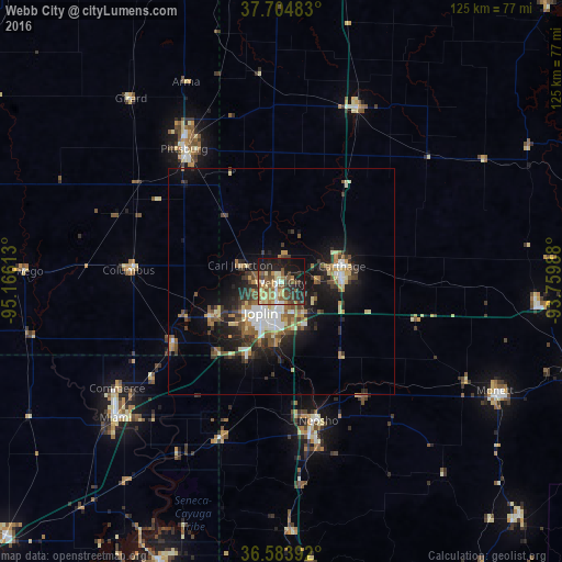
Analysis of Webb City night lights 2016
Square area 10x10 km:
 2.38%
2.38%90-99
5.27%80-89
9.01%70-79
5.1%60-69
8.67%50-59
12.24%40-49
6.8%30-39
7.99%20-29
14.63%10-19
23.47%0-9
4.42%Square area 50x50 km:
1.32%90-99
1.63%80-89
1.64%70-79
1.34%60-69
1.57%50-59
2.16%40-49
1.59%30-39
2.54%20-29
3.28%10-19
8.23%0-9
74.69%Clear (daylight) street map image can be seen on geolist.org.
Map coordinates:
37° 42' 17.4" North, 95° 9' 58.1" West
37° 8' 47.2" North, 94° 27' 46.8" West
36° 35' 2.1" North, 93° 45' 35.6" West
Some cities around Webb City sort by population:
• Joplin
8.2 km =5.1 mi,  212°
212°
• Pittsburg
36.4 km =22.6 mi,  323°
323°
• Carthage
13.9 km =8.6 mi,  76°
76°
• Miami
47.6 km =29.6 mi,  230°
230°
• Neosho
32 km =19.9 mi,  164°
164°
• Monett
53.3 km =33.1 mi,  116°
116°
• Carl Junction
9.7 km =6 mi,  290°
290°
• Grove
67.2 km =41.8 mi,  203°
203°
4413842 (p: 11,165)
Sources (retrieved 2019-11-25):
» Earth at Night: Flat Maps 2012, 2016