Neosho night lights from space
Night Light of Neosho (Missouri) from space (United States) Src. Average luminocity for 10x10km area is 29.638% and for 50x50km: 8.4495%.
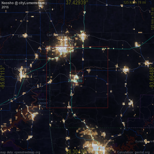
Analysis of Neosho night lights 2016
Square area 10x10 km:
 2.6%
2.6%90-99
6.49%80-89
4.55%70-79
3.25%60-69
4.55%50-59
2.27%40-49
4.87%30-39
5.52%20-29
3.9%10-19
27.92%0-9
34.09%Square area 50x50 km:
1.06%90-99
1.43%80-89
0.95%70-79
0.87%60-69
1.23%50-59
1.44%40-49
1.17%30-39
1.76%20-29
2.25%10-19
4.51%0-9
83.33%Clear (daylight) street map image can be seen on geolist.org.
Map coordinates:
37° 25' 45.8" North, 95° 4' 16.1" West
36° 52' 8.3" North, 94° 22' 4.8" West
36° 18' 15.8" North, 93° 39' 53.6" West
Some cities around Neosho sort by population:
• Joplin
27.2 km =16.9 mi,  331°
331°
• Bella Vista
44 km =27.3 mi,  168°
168°
• Carthage
34.6 km =21.5 mi,  8°
8°
• Miami
45.3 km =28.1 mi,  270°
270°
• Webb City
32 km =19.9 mi,  344°
344°
• Monett
39.7 km =24.7 mi,  80°
80°
• Carl Junction
38.5 km =23.9 mi, 332°
• Grove
47.1 km =29.3 mi,  229°
229°
4400183 (p: 12,156)
Sources (retrieved 2019-11-25):
» Earth at Night: Flat Maps 2012, 2016