Maysville night lights from space
Night Light of Maysville (Kentucky) from space (United States) Src. Average luminocity for 10x10km area is 26.5779% and for 50x50km: 3.6449%.
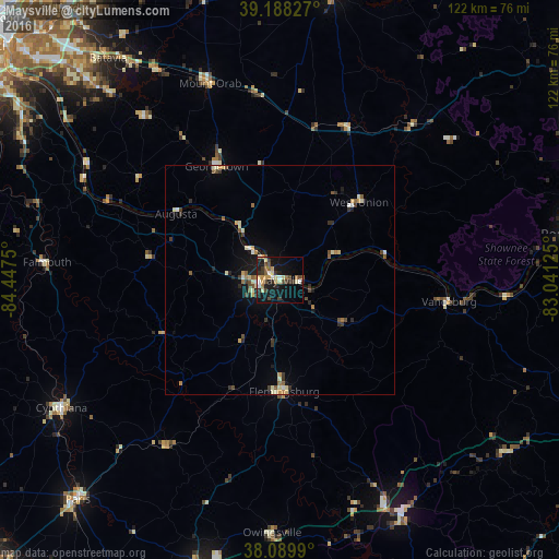
Analysis of Maysville night lights 2016
Square area 10x10 km:
 2.27%
2.27%90-99
4.55%80-89
3.25%70-79
3.41%60-69
3.08%50-59
2.6%40-49
5.03%30-39
5.52%20-29
5.52%10-19
28.08%0-9
36.69%Square area 50x50 km:
0.22%90-99
0.64%80-89
0.48%70-79
0.36%60-69
0.39%50-59
0.55%40-49
0.6%30-39
0.7%20-29
0.61%10-19
2.38%0-9
93.06%Clear (daylight) street map image can be seen on geolist.org.
Map coordinates:
39° 11' 17.8" North, 84° 26' 51" West
38° 38' 28.3" North, 83° 44' 39.7" West
38° 5' 23.6" North, 83° 2' 28.5" West
Some cities around Maysville sort by population:
• Portsmouth
65.6 km =40.8 mi,  81°
81°
• Paris
65.3 km =40.6 mi,  222°
222°
• Alexandria
66.1 km =41.1 mi,  302°
302°
• Mount Sterling
67.3 km =41.8 mi,  194°
194°
• Morehead
57.6 km =35.8 mi,  151°
151°
• Withamsville
66.4 km =41.3 mi,  314°
314°
• Hillsboro
63.4 km =39.4 mi,  10°
10°
• Cynthiana
55.4 km =34.4 mi,  239°
239°
4300152 (p: 8,819)
Sources (retrieved 2019-11-25):
» Earth at Night: Flat Maps 2012, 2016