Paris night lights from space
Night Light of Paris (Kentucky) from space (United States) Src. Average luminocity for 10x10km area is 22.284% and for 50x50km: 12.6919%.
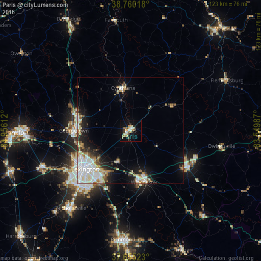
Analysis of Paris night lights 2016
Square area 10x10 km:
 3.06%
3.06%90-99
2.04%80-89
3.06%70-79
3.57%60-69
5.1%50-59
2.04%40-49
2.04%30-39
3.06%20-29
2.72%10-19
16.33%0-9
56.97%Square area 50x50 km:
3.03%90-99
3.2%80-89
1.29%70-79
1.15%60-69
1.3%50-59
1.03%40-49
1.04%30-39
1.45%20-29
2.22%10-19
5.9%0-9
78.39%Clear (daylight) street map image can be seen on geolist.org.
Map coordinates:
38° 45' 36.6" North, 84° 57' 22" West
38° 12' 35.3" North, 84° 15' 10.8" West
37° 39' 18.8" North, 83° 32' 59.5" West
Some cities around Paris sort by population:
• Lexington-Fayette
25.3 km =15.7 mi,  225°
225°
• Lexington
31.5 km =19.6 mi,  218°
218°
• Georgetown
26.7 km =16.6 mi,  270°
270°
• Winchester
25.3 km =15.7 mi,  165°
165°
• Versailles
45.2 km =28.1 mi,  247°
247°
• Mount Sterling
32 km =19.9 mi,  122°
122°
• Cynthiana
20.4 km =12.7 mi,  349°
349°
• Monticello
35.5 km =22.1 mi, 227°
4303602 (p: 9,870)
Sources (retrieved 2019-11-25):
» Earth at Night: Flat Maps 2012, 2016