Alexandria night lights from space
Night Light of Alexandria (Kentucky) from space (United States) Src. Average luminocity for 10x10km area is 31.1282% and for 50x50km: 35.96%.
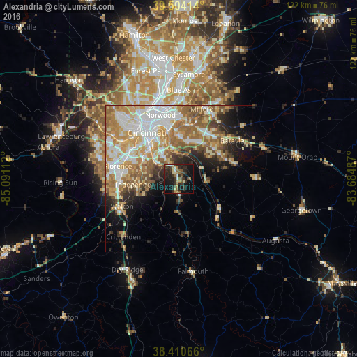
Analysis of Alexandria night lights 2016
Square area 10x10 km:
 1.95%
1.95%90-99
3.25%80-89
3.9%70-79
3.73%60-69
4.55%50-59
4.55%40-49
4.71%30-39
10.88%20-29
15.42%10-19
30.03%0-9
17.05%Square area 50x50 km:
7.37%90-99
7.67%80-89
4.85%70-79
5.85%60-69
6.65%50-59
5.81%40-49
2.91%30-39
2.84%20-29
4.83%10-19
7.79%0-9
43.42%Clear (daylight) street map image can be seen on geolist.org.
Map coordinates:
39° 30' 14.9" North, 85° 5' 28" West
38° 57' 34.2" North, 84° 23' 16.8" West
38° 24' 38.4" North, 83° 41' 5.5" West
Some cities around Alexandria sort by population:
• Independence
13.6 km =8.5 mi,  262°
262°
• Fort Thomas
13.8 km =8.6 mi,  338°
338°
• Forestville
13.4 km =8.3 mi,  16°
16°
• Highland Heights
9.9 km =6.2 mi,  325°
325°
• Withamsville
14.3 km =8.9 mi,  37°
37°
• Taylor Mill
10.3 km =6.4 mi,  294°
294°
• Cold Spring
8.2 km =5.1 mi, 327°
• Fort Wright
16.3 km =10.1 mi,  309°
309°
4282342 (p: 9,009)
Sources (retrieved 2019-11-25):
» Earth at Night: Flat Maps 2012, 2016