Maryland City night lights from space
Night Light of Maryland City (Maryland) from space (United States) Src. Average luminocity for 10x10km area is 78.3864% and for 50x50km: 72.2736%.
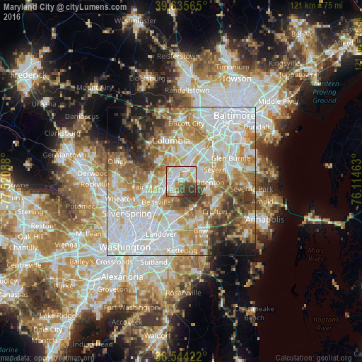
Analysis of Maryland City night lights 2016
Square area 10x10 km:
 24.35%
90-99
25.49%80-89
10.23%70-79
8.28%60-69
6.98%50-59
5.52%40-49
6.17%30-39
11.04%20-29
1.95%10-19
0%0-9
0%Square area 50x50 km:
23.8%90-99
17.08%80-89
8.73%70-79
10.67%60-69
9.58%50-59
8.17%40-49
5.35%30-39
5.58%20-29
3.77%10-19
4.35%0-9
2.9%Clear (daylight) street map image can be seen on geolist.org.
Map coordinates:
39° 38' 8.3" North, 77° 31' 15.2" West
39° 5' 31.4" North, 76° 49' 3.9" West
38° 32' 39.2" North, 76° 6' 52.7" West
Some cities around Maryland City sort by population:
• Laurel
2.8 km =1.7 mi,  286°
286°
• South Laurel
3.7 km =2.3 mi,  228°
228°
• Scaggsville
9.2 km =5.7 mi,  309°
309°
• Beltsville
10 km =6.2 mi, 230°
• Fort George G Mead Junction
4.5 km =2.8 mi,  33°
33°
• Fort Meade
6.7 km =4.2 mi,  74°
74°
• Jessup
7.3 km =4.5 mi, 29°
• Savage
5.1 km =3.2 mi,  354°
354°
4361831 (p: 16,093)
Sources (retrieved 2019-11-25):
» Earth at Night: Flat Maps 2012, 2016