Fort George G Mead Junction night lights from space
Night Light of Fort George G Mead Junction (Maryland) from space (United States) Src. Average luminocity for 10x10km area is 89.8117% and for 50x50km: 72.2816%.
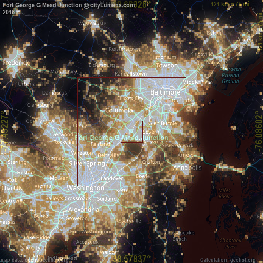
Analysis of Fort George G Mead Junction night lights 2016
Square area 10x10 km:
 30.84%
90-99
32.31%80-89
15.91%70-79
11.85%60-69
4.22%50-59
4.06%40-49
0.81%30-39
0%20-29
0%10-19
0%0-9
0%Square area 50x50 km:
23.85%90-99
16.8%80-89
8.25%70-79
10.23%60-69
9.41%50-59
9.11%40-49
6.03%30-39
6.43%20-29
4.1%10-19
3.9%0-9
1.9%Clear (daylight) street map image can be seen on geolist.org.
Map coordinates:
39° 40' 9.4" North, 77° 29' 32.2" West
39° 7' 33.4" North, 76° 47' 20.9" West
38° 34' 42.1" North, 76° 5' 9.7" West
Some cities around Fort George G Mead Junction sort by population:
• Severn
7.9 km =4.9 mi,  81°
81°
• Hanover
9.3 km =5.8 mi,  36°
36°
• Odenton
9 km =5.6 mi,  121°
121°
• Laurel
5.9 km =3.7 mi,  239°
239°
• South Laurel
8.2 km =5.1 mi,  220°
220°
• Maryland City
4.5 km =2.8 mi,  213°
213°
• Jessup
2.9 km =1.8 mi,  24°
24°
• Savage
3.3 km =2.1 mi,  293°
293°
4355322 (p: 9,505)
Sources (retrieved 2019-11-25):
» Earth at Night: Flat Maps 2012, 2016