Jessup night lights from space
Night Light of Jessup (Maryland) from space (United States) Src. Average luminocity for 10x10km area is 94.599% and for 50x50km: 72.1454%.
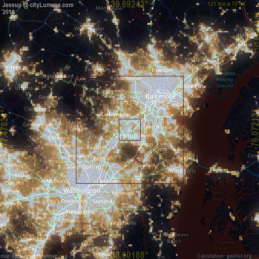
Analysis of Jessup night lights 2016
Square area 10x10 km:
 38.96%
90-99
38.15%80-89
13.31%70-79
9.58%60-69
0%50-59
0%40-49
0%30-39
0%20-29
0%10-19
0%0-9
0%Square area 50x50 km:
23.53%90-99
16.97%80-89
8.3%70-79
10.03%60-69
9.37%50-59
9.23%40-49
6.03%30-39
6.51%20-29
4.05%10-19
4.37%0-9
1.61%Clear (daylight) street map image can be seen on geolist.org.
Map coordinates:
39° 41' 32.7" North, 77° 28' 42.2" West
39° 8' 57.4" North, 76° 46' 30.9" West
38° 36' 6.8" North, 76° 4' 19.7" West
Some cities around Jessup sort by population:
• Severn
6.8 km =4.2 mi,  101°
101°
• Hanover
6.6 km =4.1 mi,  42°
42°
• West Elkridge
7.7 km =4.8 mi,  32°
32°
• Laurel
8.4 km =5.2 mi,  228°
228°
• Maryland City
7.3 km =4.5 mi,  209°
209°
• Fort George G Mead Junction
2.9 km =1.8 mi,  204°
204°
• Fort Meade
5.3 km =3.3 mi,  148°
148°
• Savage
4.4 km =2.7 mi,  253°
253°
4049032 (p: 7,137)
Sources (retrieved 2019-11-25):
» Earth at Night: Flat Maps 2012, 2016