Fort Meade night lights from space
Night Light of Fort Meade (Maryland) from space (United States) Src. Average luminocity for 10x10km area is 82.5422% and for 50x50km: 71.704%.
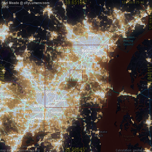
Analysis of Fort Meade night lights 2016
Square area 10x10 km:
 24.03%
90-99
30.68%80-89
13.47%70-79
8.77%60-69
4.55%50-59
5.03%40-49
4.55%30-39
8.93%20-29
0%10-19
0%0-9
0%Square area 50x50 km:
22.79%90-99
15.87%80-89
8.23%70-79
10.82%60-69
9.83%50-59
9.45%40-49
6.54%30-39
6.72%20-29
4.95%10-19
4.28%0-9
0.53%Clear (daylight) street map image can be seen on geolist.org.
Map coordinates:
39° 39' 5.9" North, 77° 26' 46.9" West
39° 6' 29.3" North, 76° 44' 35.6" West
38° 33' 37.6" North, 76° 2' 24.4" West
Some cities around Fort Meade sort by population:
• Severn
5 km =3.1 mi,  50°
50°
• Hanover
9.6 km =6 mi,  9°
9°
• Odenton
4.6 km =2.9 mi,  125°
125°
• Laurel
9.1 km =5.7 mi,  263°
263°
• South Laurel
10.2 km =6.3 mi,  245°
245°
• Maryland City
6.7 km =4.2 mi, 254°
• Jessup
5.3 km =3.3 mi,  328°
328°
• Savage
7.7 km =4.8 mi,  295°
295°
7257909 (p: 9,327)
Sources (retrieved 2019-11-25):
» Earth at Night: Flat Maps 2012, 2016