Beltsville night lights from space
Night Light of Beltsville (Maryland) from space (United States) Src. Average luminocity for 10x10km area is 87.4464% and for 50x50km: 75.0025%.
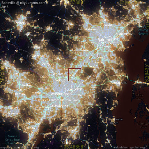
Analysis of Beltsville night lights 2016
Square area 10x10 km:
 25.65%
90-99
27.92%80-89
17.37%70-79
17.05%60-69
8.6%50-59
3.41%40-49
0%30-39
0%20-29
0%10-19
0%0-9
0%Square area 50x50 km:
24.02%90-99
19.15%80-89
10.12%70-79
12.21%60-69
9.56%50-59
7%40-49
4.32%30-39
4.31%20-29
3.19%10-19
3.53%0-9
2.61%Clear (daylight) street map image can be seen on geolist.org.
Map coordinates:
39° 34' 44" North, 77° 36' 38.2" West
39° 2' 5.4" North, 76° 54' 26.9" West
38° 29' 11.6" North, 76° 12' 15.7" West
Some cities around Beltsville sort by population:
• College Park
6.5 km =4 mi,  202°
202°
• South Laurel
6.3 km =3.9 mi,  51°
51°
• Greenbelt
4.4 km =2.7 mi,  140°
140°
• Fairland
6.3 km =3.9 mi,  316°
316°
• Calverton
3.5 km =2.2 mi, 315°
• Adelphi
6.6 km =4.1 mi,  237°
237°
• Goddard
6.9 km =4.3 mi, 137°
• Hillandale
5.8 km =3.6 mi,  260°
260°
4348353 (p: 16,772)
Sources (retrieved 2019-11-25):
» Earth at Night: Flat Maps 2012, 2016