Marco Island night lights from space
Night Light of Marco Island (Florida) from space (United States) Src. Average luminocity for 10x10km area is 32.8214% and for 50x50km: 8.3367%.
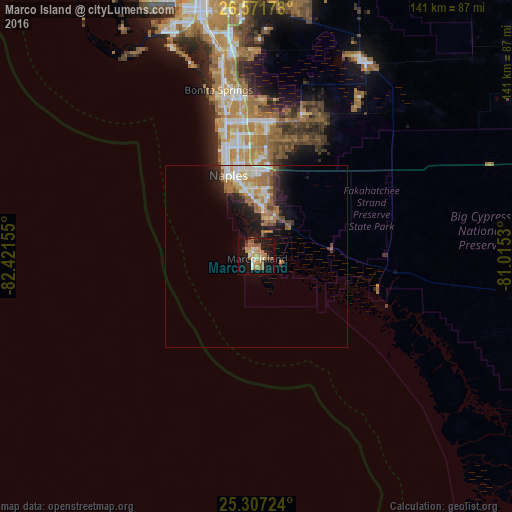
Analysis of Marco Island night lights 2016
Square area 10x10 km:
 1.79%
1.79%90-99
4.37%80-89
3.57%70-79
3.37%60-69
13.29%50-59
6.35%40-49
2.38%30-39
1.79%20-29
3.37%10-19
42.06%0-9
17.66%Square area 50x50 km:
1.05%90-99
1.53%80-89
0.76%70-79
1.04%60-69
2.49%50-59
1.04%40-49
0.72%30-39
0.71%20-29
1.92%10-19
5.6%0-9
83.13%Clear (daylight) street map image can be seen on geolist.org.
Map coordinates:
26° 34' 18.4" North, 82° 25' 17.6" West
25° 56' 28.4" North, 81° 43' 6.3" West
25° 18' 26.1" North, 81° 0' 55.1" West
Some cities around Marco Island sort by population:
• Bonita Springs
44.7 km =27.8 mi,  352°
352°
• Estero
56 km =34.8 mi, 350°
• Golden Gate
27.5 km =17.1 mi,  4°
4°
• East Naples
22.4 km =13.9 mi, 347°
• Naples
23.7 km =14.7 mi,  340°
340°
• Pelican Bay
33.4 km =20.8 mi, 344°
• Naples Park
36.8 km =22.9 mi, 345°
• Naples Manor
16.4 km =10.2 mi,  357°
357°
4163388 (p: 17,690)
Sources (retrieved 2019-11-25):
» Earth at Night: Flat Maps 2012, 2016