Pelican Bay night lights from space
Night Light of Pelican Bay (Florida) from space (United States) Src. Average luminocity for 10x10km area is 65.6786% and for 50x50km: 25.2678%.
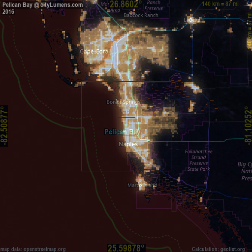
Analysis of Pelican Bay night lights 2016
Square area 10x10 km:
 14.68%
90-99
19.44%80-89
10.12%70-79
17.46%60-69
3.97%50-59
2.38%40-49
0.99%30-39
2.78%20-29
15.08%10-19
13.1%0-9
0%Square area 50x50 km:
3.1%90-99
4.16%80-89
2.67%70-79
4.5%60-69
7.74%50-59
3.51%40-49
3.36%30-39
2.87%20-29
5.54%10-19
9.23%0-9
53.33%Clear (daylight) street map image can be seen on geolist.org.
Map coordinates:
26° 51' 36.7" North, 82° 30' 31.6" West
26° 13' 52.3" North, 81° 48' 20.3" West
25° 35' 55.6" North, 81° 6' 9.1" West
Some cities around Pelican Bay sort by population:
• Bonita Springs
12.4 km =7.7 mi,  12°
12°
• Estero
23 km =14.3 mi,  359°
359°
• Golden Gate
12 km =7.5 mi,  113°
113°
• East Naples
11 km =6.8 mi,  159°
159°
• Naples
9.9 km =6.2 mi,  174°
174°
• San Carlos Park
26.3 km =16.3 mi,  0°
0°
• Naples Park
3.4 km =2.1 mi,  353°
353°
• Naples Manor
17.7 km =11 mi,  153°
153°
4168095 (p: 6,346)
Sources (retrieved 2019-11-25):
» Earth at Night: Flat Maps 2012, 2016