Naples Park night lights from space
Night Light of Naples Park (Florida) from space (United States) Src. Average luminocity for 10x10km area is 61.8631% and for 50x50km: 26.8959%.
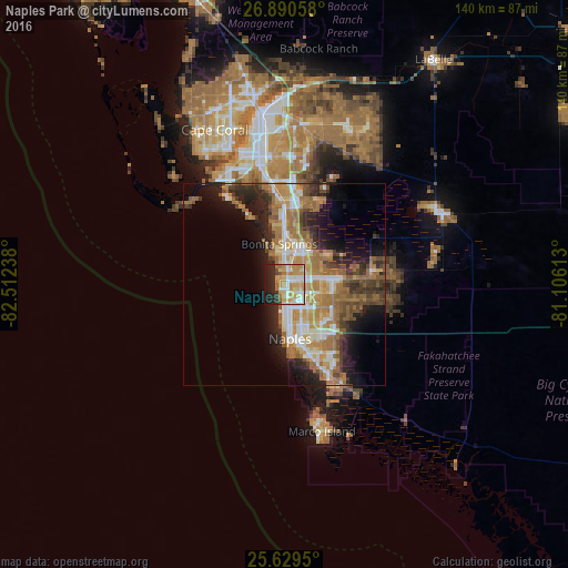
Analysis of Naples Park night lights 2016
Square area 10x10 km:
 10.91%
90-99
12.9%80-89
12.5%70-79
19.25%60-69
8.93%50-59
0.79%40-49
2.18%30-39
3.17%20-29
14.88%10-19
14.48%0-9
0%Square area 50x50 km:
3.28%90-99
4.57%80-89
2.75%70-79
4.85%60-69
8.04%50-59
3.64%40-49
3.69%30-39
3.1%20-29
6.64%10-19
8.81%0-9
50.64%Clear (daylight) street map image can be seen on geolist.org.
Map coordinates:
26° 53' 26.1" North, 82° 30' 44.6" West
26° 15' 42.3" North, 81° 48' 33.3" West
25° 37' 46.2" North, 81° 6' 22.1" West
Some cities around Naples Park sort by population:
• Bonita Springs
9.2 km =5.7 mi,  19°
19°
• Estero
19.6 km =12.2 mi,  0°
0°
• Golden Gate
14 km =8.7 mi,  125°
125°
• East Naples
14.4 km =8.9 mi,  162°
162°
• San Carlos Park
22.9 km =14.2 mi, 1°
• Sanibel
29.7 km =18.5 mi,  314°
314°
• Fort Myers Beach
25.5 km =15.8 mi,  326°
326°
• Pelican Bay
3.4 km =2.1 mi,  173°
173°
4165576 (p: 5,967)
Sources (retrieved 2019-11-25):
» Earth at Night: Flat Maps 2012, 2016