Golden Gate night lights from space
Night Light of Golden Gate (Florida) from space (United States) Src. Average luminocity for 10x10km area is 69.7103% and for 50x50km: 24.5935%.

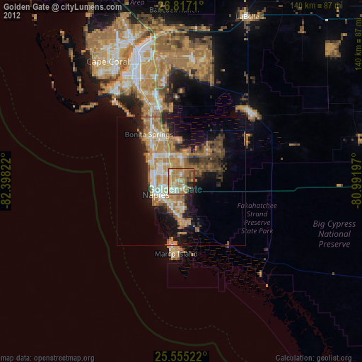
Analysis of Golden Gate night lights 2016
Square area 10x10 km:
 7.94%
7.94%90-99
16.27%80-89
5.56%70-79
14.68%60-69
27.78%50-59
13.69%40-49
7.14%30-39
4.76%20-29
2.18%10-19
0%0-9
0%Square area 50x50 km:
2.87%90-99
3.96%80-89
2.57%70-79
4.2%60-69
6.98%50-59
3.49%40-49
3.62%30-39
3.39%20-29
5.44%10-19
9.61%0-9
53.87%Clear (daylight) street map image can be seen on geolist.org.
Map coordinates:
26° 49' 1.6" North, 82° 23' 53.6" West
26° 11' 16.3" North, 81° 41' 42.3" West
25° 33' 18.8" North, 80° 59' 31.1" West
Some cities around Golden Gate sort by population:
• Bonita Springs
18.8 km =11.7 mi,  333°
333°
• East Naples
9 km =5.6 mi,  232°
232°
• Naples
11.3 km =7 mi,  243°
243°
• Marco Island
27.5 km =17.1 mi,  184°
184°
• Marco
24.2 km =15 mi,  188°
188°
• Pelican Bay
12 km =7.5 mi,  293°
293°
• Naples Park
14 km =8.7 mi,  305°
305°
• Naples Manor
11.5 km =7.1 mi,  195°
195°
4156920 (p: 23,961)
Sources (retrieved 2019-11-25):
» Earth at Night: Flat Maps 2012, 2016