Old Saybrook night lights from space
Night Light of Old Saybrook (Connecticut) from space (United States) Src. Average luminocity for 10x10km area is 23.5341% and for 50x50km: 8.8654%.
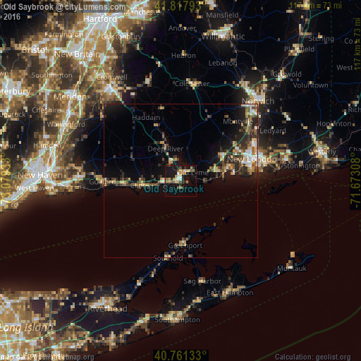
Analysis of Old Saybrook night lights 2016
Square area 10x10 km:
 0.97%
0.97%90-99
2.92%80-89
2.92%70-79
3.73%60-69
4.55%50-59
3.41%40-49
3.25%30-39
1.95%20-29
5.03%10-19
31.01%0-9
40.26%Square area 50x50 km:
0.71%90-99
0.96%80-89
1.22%70-79
1.16%60-69
1.08%50-59
1.21%40-49
1.61%30-39
1.84%20-29
3.28%10-19
5.79%0-9
81.14%Clear (daylight) street map image can be seen on geolist.org.
Map coordinates:
41° 49' 4.5" North, 73° 4' 45.6" West
41° 17' 30.4" North, 72° 22' 34.3" West
40° 45' 40.8" North, 71° 40' 23.1" West
Some cities around Old Saybrook sort by population:
• New London
24.2 km =15 mi,  72°
72°
• Guilford
25.5 km =15.8 mi,  269°
269°
• Waterford
20.8 km =12.9 mi, 74°
• Madison
18.6 km =11.6 mi, 265°
• Groton
25.7 km =16 mi,  75°
75°
• East Haddam
19.3 km =12 mi,  338°
338°
• Conning Towers-Nautilus Park
27.7 km =17.2 mi, 67°
• Southold
25.6 km =15.9 mi,  189°
189°
4840035 (p: 10,627)
Sources (retrieved 2019-11-25):
» Earth at Night: Flat Maps 2012, 2016